June 29, 1992 LP Storm
I lived in Colorado and Wyoming for a total of 32 years. Even though this area does not have an incidence of tornadoes equaling that in Oklahoma or Texas, the visiblity is better and an observant person is likely to see landspouts every year or so, and a tornado occasionally.
Summer 1970 Goshen County, Wyoming I spent the summer working on the family farm. On this particular June day I was cultivating corn northwest of Lagrange. A funnel cloud dropped from a thundercloud to my northwest, and raised debris above the ground surface in some fields north of me. I only recall that as the tornado passed a half-mile away north of me a very strong flow of air near the surface pulled dust throughout my field toward the tornado. I was now pelted with marble-sized hail.
July 22, 1973 Laramie County, Wyoming Most of the tornadoes I have seen (including those in Denver in 1987-1988) are landspouts or Type-A tornadoes. On July 22, 1973 I watched a line of 4 or 5 such landspouts, evenly spaced, threaten the grandstands of Cheyenne Frontier Days. They formed on a windshift line on the flank of a thunderstorm perhaps 5 or 6 miles west of the city. I have produced a couple of slides of these landspouts that are on one or more pages of this site.
 Click here to see a line of landspouts.
Summer 1979 Cheyenne, Wyoming The big storm of this year was the F-3 tornado that did so much damage across the northern part of the city on July 16. The tornado passed a hundred meters from my home, but I was not there at the time. I was standing on a balconey on a high building watching the tornado a mile or so to the south. I never heard anything unusual; no freight train, no squealing pigs, no sounds of destruction. I had no sense of size or distance. What appeared to me as shingles, and a chair orbiting the funnel were, in fact, 4x8 foot plywood sheets and a section of truss-work torn from a hanger at the airport. The tornado managed to lift debris to a much greater height than I would have thought possible.
The second tornado I witnessed this summer occurred in August. I was working on a construction site northwest of Cheyenne, Wyoming. For some reason I became aware of what looked like a dust devil to the northeast. Not dusty was it, but full of paper and shiny things. This was moving toward me. Above the column of debris there was a thread of distortion of the background clouds just like refraction in a mirage. I could follow this thread first upward then horizontally through the sky for miles. It terminated in a short funnel at the base of a thunderstorm above Cheyenne. I was stunned to find an F0 tornado sneaking around unnoticed. The parent cloud was headed east, so this vortex was being stretched more with each passing minute. Yet it lasted long enough for me to drive a quarter of a mile to a hill-top and join a fellow sitting atop his paddle-scraper watching the same thing. A few days later I spoke to woman who lived near where the tornado had been on the ground. The nearly invisible vortex had passed by her house and struck an old garbage dump where it picked up hundreds (thousands?) of discarded cans carrying them off gleefully with a great clanging sound.
Memorial Day 1985 Goshen County, Wyoming My brother and I were constructing an irrigation system on a hay field just southeast of Lagrange. In mid afternoon, as dry thunderstorms passed overhead, the wind, which had been very annoying all day, suddenly gusted to perhaps 80mph out of the south. The structures we were assembling were well anchored to the ground, but I recall being worried that we were going to lose our work to the gale. After about 15 or 20 seconds the wind dropped back down to 20-25mph. Momentarily I happened to look toward some wheat fields on a hill to the northeast and saw an enormous dust-devil that was perhaps 100-200 feet across and 200-300 feet high. It was rotating ferociously. In the thunderhead above was a short tongue of funnel cloud. My brother and I looked at one another and said "Woah!"
Summers 1987 and 1988 Denver, Colorado Landspouts west and southwest of downtown Denver occured in exactly the same sort of situation as the landspouts west of Cheyenne in 1973.
Summer 1991 Hawk Springs Reservoir, Wyoming The fishermen that sport this lake are not detered by rain nor sleet nor gloom of night. However, a landspout that was clearly visible part way to the ground roughed up a patch of the lake surface about fifty meters in diameter. I have never seen fishermen weigh anchor and head in to shore so quickly in my life.
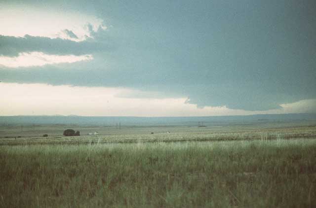
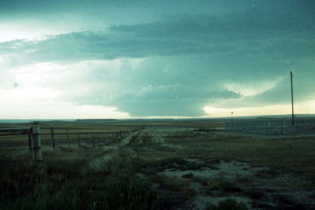
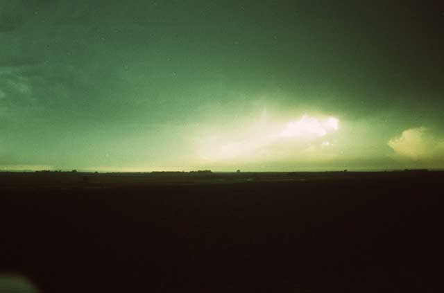
June 29, 1992 Goshen County, Wyoming I had never heard of LP storms before reading Howard Bluestein's book, but I had noticed them. In June 1992 my brother and I had to ferry some heavy equipment between Lingle and Lagrange, Wyoming. A strong east wind blew the entire day and dragged in so much moisture that the lower air became hazy and brownish-green (refer to the slide). There were tornado warnings covering the area at the time, and I saw several funnels drop out of an extremely mean-looking thundercloud, but no tornadoes. This thunderhead was rotating and had striations around it and also around its wall cloud. As we drove along back roads I watched the wall cloud become bell-shaped. I have no idea if this is truly a wall cloud, but it then develops another wall cloud at a lower level with virga below. Meanwhile the hefty column of the thunderhead was disappearing. Finally, all that remained were two thin columns, sitting atop pedestals with an anvil above (refer to drawing). I now wonder if this LP storm had two counter-rotating updrafts within it. I was always on the south flank of this storm and only know that the southern flank showed counterclockwise rotation. It may have been clockwise to the north. Has anyone ever observed something similar?
| 6:20 pm west view | 7:30 pm west view | 8:30 pm north view |
|---|---|---|
|
|
|
|
| There is a single distinct lowering of the cloud base far off at the western horizon. The cloud was rotating rapidly, and nearer the camera is a long tail of a cloud that wrapped around to the north and entered the northwest flank of the storm. | There are two distinct lowerings of the cloud base at this time. One has a short tail that extends toward the south. | This photo late in the day shows the remains of the LP storm, a distinct pedestal and tower above, as it passed to the north of me. Note the greenish brown layer near the earth composed of moisture and dust moved by the relentless east wind. |
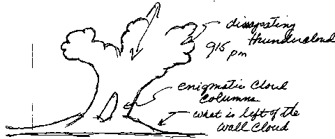
The drawing below is from my notebook, and attempts to convey what the LP storm looked like near the end of its life as the gloom of night fell on the ranch. The wall cloud or base is saucer-shaped, with two columnar towers rising above capped by two anvils and some other obscurance. Because I knew nothing of LP storms at the time, I simply catalogued the columns as enigmatic.
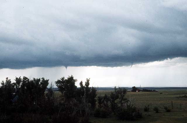
June 26, 1999 Goshen County, Wyoming I no longer live in Goshen County, Wyoming, but my brother does. Two LP storms pass through the area this day; both originate over Laramie Peak. One passes over Lagrange, Wyoming and takes a right turn toward Kimbal and eventually Imperial, Nebraska. The other occurs hours later and runs almost straight east on the Goshen County, Laramie County line about 5 miles south of Lagrange. My brother's ranch is northwest of Lagrange. In the first storm he is pelted by hail, not heavy, but of huge stones. Some of these are the size of a small fist and shaped about the same. Days later the cows are still sore from this misfortune. There are two tornado funnels and one full tornado that touches down two miles southwest of his home.
The second storm is far enough to the south that my brother can get a very good look at it. The cloud itself is black and has an umbrella-shaped (my brother would say saucer-shaped) wall cloud below. The whole thing appears to be rotating quickly. Now and then he thinks that the cloud shoots out a thin funnel toward earth, but these dissipate almost immediately and none of them reach the ground. "Scariest cloud he has ever seen," is how he described it.
The timing of terrible hail storms we have suffered over the years suggests that LP storms strike the Goshen Hole country almost always in the last 10 days of June. This happens when a sort of dry-line typically hangs across the area.
May 4, 2000 Goshen County, Wyoming During the night of May 4 my brother had a center-pivot irrigation system destroyed by an unobserved storm. Another such system was destroyed in exactly the same manner some 6 miles to the east in Nebraska. Although no one actually observed the destruction of the system, there is strong evidence to suggest that it was a tornado. The irrigation system weighs between 25 and 60 tons depending on how much water it contains. Damage to the hay field in which it sat showed that only the end tower dragged across the ground. There being no evidence of any drag marks for the other 6 segments of the system suggests that they were airborne during their journey. The system was crumpled and over-turned about 50 feet to the east of where it originally sat. What is most interesting about this, assuming that it was indeed tornado damage, is the number of tornadoes that have visited a small area in eastern Wyoming over the past few decades. Statistics indicate that this region has 1 tornado per 10,000 square miles per year. In three decades I can list 8 or more in a 1,000 square mile area. Could the unusual terrain be the cause, or is this just the expected variation of a small sample?